As we continue to advance in technology, the amount of data that we collect and process increases significantly. One such type of data that is becoming more prevalent in various industries is point cloud data. But what exactly is point cloud data?
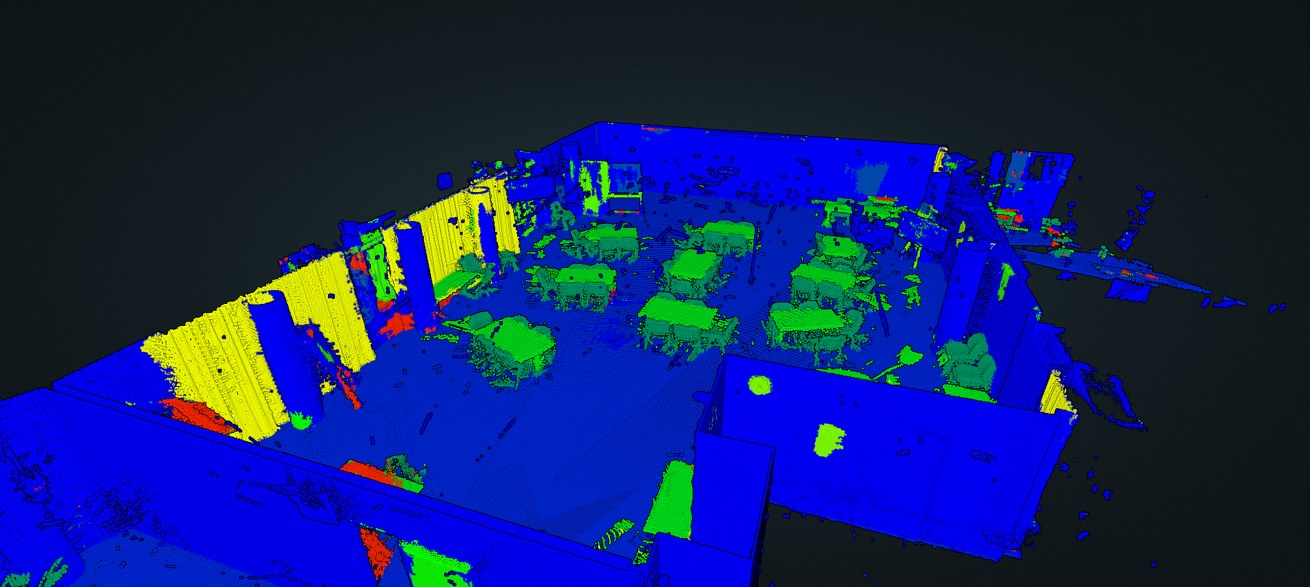
In simple terms, point cloud data is a collection of 3D points that represent the surface of an object or a space. These points are typically captured through scanning technologies such as LiDAR or photogrammetry, and they can be used for a variety of applications such as creating 3D models, measuring distances, and detecting changes over time. As a professional writer, it’s essential to understand the significance of point cloud data and how it’s transforming industries such as architecture, engineering, construction, and more. In this article, we’ll explore the basics of point cloud data, its uses, and its potential to revolutionize the way we work and live.
Point cloud data is a set of data points in space. It is generally used in 3D imaging applications, such as 3D scanning or 3D photography. Point cloud data is typically represented as a collection of points, each point having a set of coordinates in space. Point clouds can be used to create 3D models of any surface or object.
- Acquire the point cloud data from a 3D scanning device or other source.
- Use software to process the data, such as filtering out noise and aligning the points.
- Create a mesh from the point cloud data.
- Use the mesh to create a 3D model.
- Export the 3D model to a file format such as OBJ or STL.
| Point Cloud Data | Image Data |
|---|---|
| Represented as a collection of points | Represented as a matrix of pixels |
| Used to create 3D models | Used to create 2D images |
| Requires more processing | Less processing required |

What is Point Cloud Data?
Point cloud data is a digital representation of an object or scene in three-dimensional space. It is made up of millions of points that are used to generate an accurate 3D model. Point cloud data is used for a variety of applications such as 3D modeling, computer vision, and robotics. In this article, we will discuss what point cloud data is, how it is used, and the benefits of using it.
How is Point Cloud Data Generated?
Point cloud data is typically generated using laser scanners or other 3D imaging technologies. These scanners capture millions of points in a single scan, allowing for a detailed 3D representation of an object or scene. These points can then be used to generate a 3D model of the object or scene.
The point cloud data is usually generated in a specific file format. This file format is then used to create a 3D model that can be used in various applications. This 3D model can also be used to generate a virtual environment for virtual reality applications.
What are the Benefits of Point Cloud Data?
Point cloud data has a variety of benefits for 3D modeling, computer vision, and robotics. For 3D modeling, point cloud data can be used to generate an accurate 3D model of an object or scene. This 3D model can then be used for animation and rendering, or to create virtual environments for virtual reality applications.
For computer vision, point cloud data can be used to detect objects in an image or scene. This can be used for object recognition, motion tracking, and other applications. For robotics, point cloud data can be used for navigation, mapping, and other tasks.
Frequently Asked Questions
Point cloud data is a set of data points in a 3D coordinate system which represents a 3D object or a 3D environment. It is used in various fields such as geomatics, architecture, engineering, construction, and computer graphics.
What is point cloud data?
Point cloud data is a set of 3D data points that represent a 3D object or environment. It is used to capture the measurements of an object or environment in a 3D space. The data points are usually collected using a 3D scanner and can be used to generate 3D models, CAD drawings, and other digital representations of physical objects.
Point cloud data can be used in a variety of applications such as surveying, architecture, engineering, construction, and animation. It is also used in medical imaging, industrial design, and 3D printing. Point cloud data can be used to create 3D models of objects or environments, which can be used for virtual reality and augmented reality applications.
What is 3D scanning?
3D scanning is a process of collecting 3D data points of a physical object or environment. It involves using a 3D scanner which is a device that uses light to measure the physical object or environment and capture a set of 3D data points. The data points are then used to generate a 3D model of the object or environment. 3D scanners are used in a variety of applications such as surveying, architecture, engineering, construction, and animation.
The 3D scanner captures a set of data points which are then used to generate a 3D model. This model can be used to create a virtual reality or augmented reality environment, or to create 3D printable models. 3D scanners can also be used to capture the measurements of objects for industrial design, medical imaging, and other applications.
What are the benefits of using point cloud data?
Point cloud data has many benefits over traditional methods of measuring and capturing data. It is more accurate and can capture a higher level of detail than traditional methods. Point cloud data is also faster and more efficient than traditional methods. It can be used to capture a 3D model of an object or environment in a fraction of the time it would take to do the same with traditional methods.
Point cloud data can also be used to create more accurate and detailed 3D models. This can be used to create 3D printable models, virtual reality or augmented reality environments, or to generate CAD drawings and other digital representations of physical objects. Point cloud data can also be used to create accurate measurements for industrial design, medical imaging, and other applications.
What is the difference between point cloud data and 3D models?
Point cloud data is a set of data points in a 3D coordinate system which represents a 3D object or environment. It is used to capture the measurements of an object or environment in a 3D space. 3D models are digital representations of physical objects and environments created from point cloud data.
Point cloud data is the source data used to generate 3D models. It can be used to capture measurements of an object or environment in a 3D space, which can then be used to generate a 3D model. 3D models are more accurate and detailed than point cloud data, as they take into account the measurements and shape of the object or environment. 3D models can be used for virtual reality and augmented reality applications, as well as for 3D printing and other digital representations of physical objects.
What is point cloud data used for?
Point cloud data is used in a variety of applications, such as surveying, architecture, engineering, construction, and animation. It can be used to capture the measurements of an object or environment in a 3D space, which can then be used to generate a 3D model. 3D models can be used for virtual reality and augmented reality applications, as well as for 3D printing and other digital representations of physical objects.
Point cloud data can also be used to create accurate measurements for industrial design, medical imaging, and other applications. It can also be used to create CAD drawings of objects or environments. Point cloud data can be used for a variety of other applications, such as creating terrain maps and topographical data, as well as for archaeological and geological studies.
In conclusion, point cloud data is a powerful tool that allows us to capture and analyze the physical world in an unprecedented way. By using laser scanners, cameras, and other sensors, we can create detailed 3D models of real-world objects and environments that can be used in a wide range of applications, from architecture and engineering to entertainment and virtual reality. With the increasing availability of point cloud data and the development of new tools and techniques for working with it, we are only beginning to scratch the surface of what is possible.
As we move into the future, it is clear that point cloud data will continue to play a vital role in shaping the way we interact with the world around us. Whether it is used to create more realistic and immersive virtual environments, improve the accuracy and efficiency of construction projects, or develop new technologies and innovations, the potential of point cloud data is truly limitless. As a professional writer, it is exciting to see the ways in which this technology is being used to push the boundaries of what we thought was possible, and I look forward to seeing where it will take us next.